It doesn’t take long to get your first jaw-dropping view of Arches National Park. It happens about 30 seconds after you’ve entered, as you take your first right turn and begin a steep uphill ascent in the shadow of a massive, sheer red cliff that runs alongside the road. The stark stone facade seems to be warning visitors that you’re no longer in the domain of the human, but rather, you’ve entered a geological realm forged by millions of years of accumulated history, unrelenting weather and erosion, the time scales and physical dimensions of which you cannot begin to fathom. Your rules and limits do not apply.
The drive through Arches feels more like you’re visiting a theme park than a national park, as if you were riding on a slow-moving trolley through a massive, purpose-built stage scene. It feels like you’re visiting the park in Westworld, though that couldn’t possibly be true. No, those sprawling, dramatic desert and mountain shots from the early seasons of the show were shot all the way in Canyonlands National Park, the entrance of which lies a whopping 10 miles away, providing you with yet another national park you can check off your list while cruising through Utah.
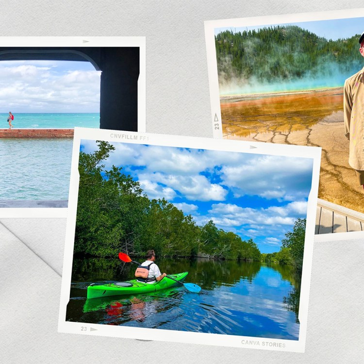
Whether you do it over the course of a long weekend or an entire week, that’s more or less the agenda of a trip spent driving across southern Utah. One world-class, bucket-list scenic destination today, two more tomorrow. Ho-hum. You can knock out Utah’s “Mighty 5” slate of national parks in one clean pass, while adding in a handful of national monuments, forests and recreation areas for good measure.
Of course, when it comes to traveling in the midst of the ongoing pandemic, such a journey makes all the more sense. Whether you hunker down in an RV or a tent, find a secluded cabin or a boutique hotel, the wide open expanse of the state’s natural beauty beckons.
Arches
The main road through Arches spans 18 miles in each direction, in addition to several potential side roads you can take through the park. In a hurry, you could do a full circuit while stopping for some photos in about three hours. If you have time for a few quick walks, head to Balanced Rock, The Windows — pop around the back of the formation for your only chance to see both at once — and right across the same parking area, the domed Double Arch.
Planning for a full day visit is an even better choice, though, or you can consider a two-day approach. Spend a night in Moab, a five-mile jaunt away from the park’s entrance, and incorporate either a sunset or a sunrise expedition into the itinerary.
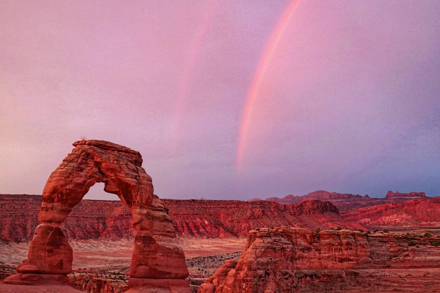
Choosing the latter, I embarked for the three-mile hike to Delicate Arch – the scene showcased on the Utah license plate — in the pitch black at 5 a.m. It was a surreal experience driving through, like being on a movie set with none of the stage lights on, and therefore having no idea of the majesty of what towered next to you on the road. Arches was recently declared an official International Dark Sky Park, so there are no streetlights to set the scene.
I wrongly assumed that by the time I was underway, the whispers of dawn would provide sufficient lighting for an easily marked and plotted trail, and therefore departed with neither a head lamp nor enough time spent researching my route. I soon found myself on the literal precipice, staring straight down at a grisly demise, after I missed a turn and ventured up an incorrect and unfortunate side path. What I took to be one uphill trail was more like a comb, with a series of narrow prongs extending up into the sky from a shared base. Retracing my steps, I eventually found a more proper path across and then up, and still managed to make it up to the beautiful scene in time to witness sunrise.
The rain I feared would ruin the affair and mask the sunrise instead provided a welcome surprise of a rainbow … no two rainbows! The whole lot of half a dozen people who braved the sunrise trek — none of whom managed a seamless journey up, I should add, though all of our wrong turns and missteps occurred in different places — went full Double Rainbow Guy on the scene.
On the way back down, I could only laugh at myself for my circuitous and almost dead-end journey. The trail is quite well marked out with signage. If only you could see them. With a mildly harrowing moment of being lost, alone in the dark on a steep mountain in the middle of the Utah desert now behind me, I figured my Official Road Adventure for the day was already completed. I was wrong.
To Bryce
I set off from Arches for a drive through Capitol Reef National Park, en route to Utah Scenic Byway 12. Dubbed an “All-American Road,” and “A Journey Through Time Scenic Byway,” the 122-mile stretch of pavement slices through Grand Staircase-Escalante National Monument and heads straight to Bryce Canyon National Park. Along the way it’ll take you through a handful of wholly different landscapes and climates, and an endless array of breathtaking vistas, nature showing off with its prettiest colors and patterns and features, ever the nattily adorned peacock clamoring for your attention.
While passing through the bottom of Capitol Reef’s curvaceous canyons, the July sunlight, scorching the landscape with 110 degrees of wattage only moments prior, disappeared entirely. The sky turned black and the clouds opened, unleashing a wild hailstorm that prompted me to pull over. The side of the road was no place to be, though, especially as the ice gave way to biblical rain and gushes of muddy water began streaming past. Staying here might be safe — until the car got washed away from the building currents.
I decided to make a run for it, and it was a good thing I did, as park rangers closed the road off behind me right as my phone pinged with an emergency warning, telling me I was in a life threatening flash food and needed to flee. The road was closed off to new arrivals behind me, and within seconds of my passage across another watery stretch of pavement half a mile away, a trickle of water across the road turned into a torrent at the flick of a switch, closing the road once and for all. No intervention from park rangers required this time — a mudslide speaks for itself.
Emerging from the canyon and having reached higher ground, I encountered a sight I wasn’t expecting when I set off for southern Utah in July: ice-strewn and frigid green fields. My vehicle climbed nearly two miles of elevation and the temperature dropped to 50 degrees, with lush forests and roaming cattle replacing the red sands and harsh, rugged environs of the desert floor.
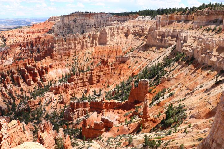
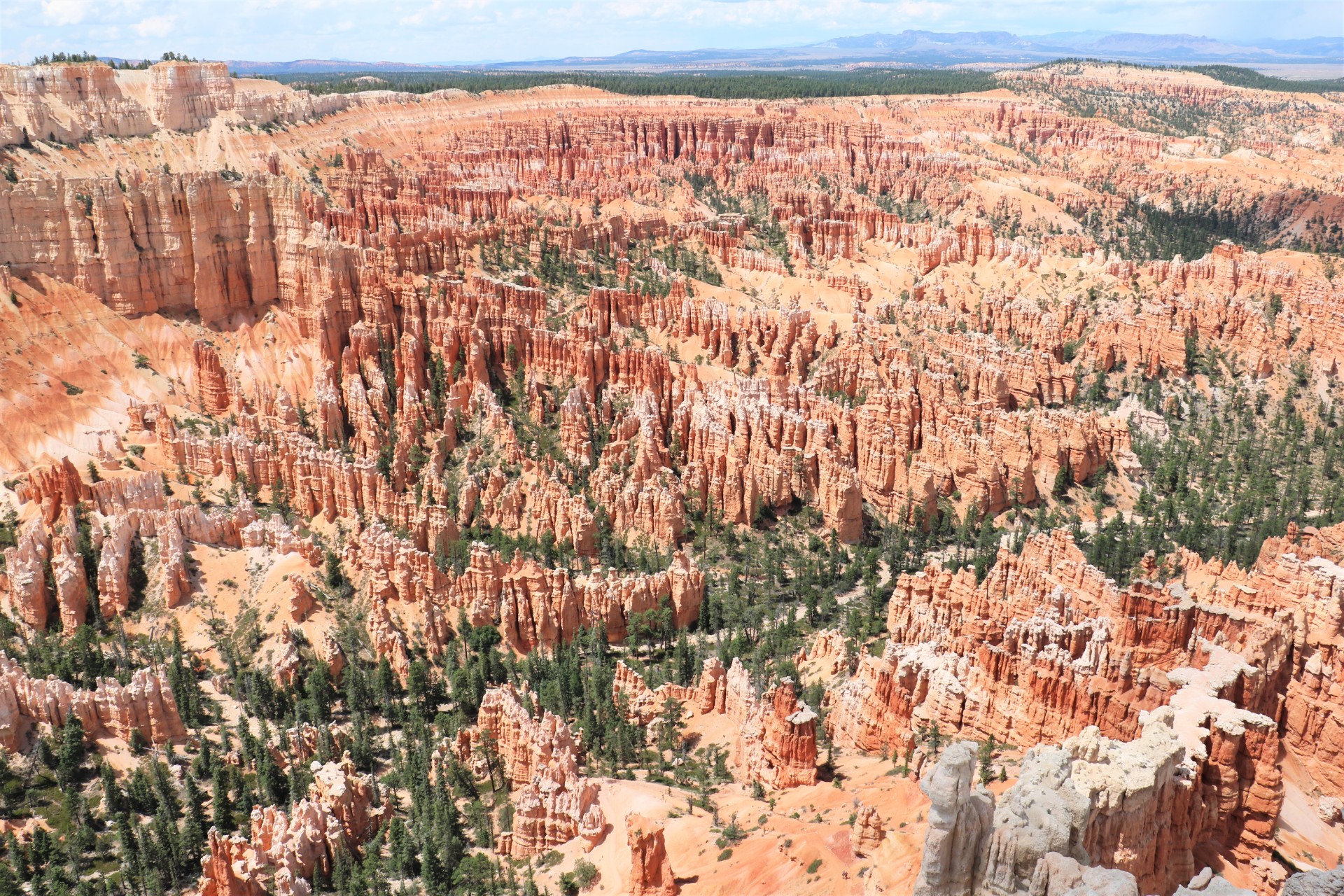
After a night spent in Boulder, a logical way station between park, it was onward to Bryce Canyon. As opposed to Arches, this park isn’t a drive-through roadside spectacle. You must leave your air-conditioned environs to get a glimpse of its amphitheaters and famous hoodoos, the countless white and orange eroded spires that lie within them.
The full out-and-back roadway offers myriad viewpoints, though in a pinch you can skip almost all of them after the first handful. Visit the main Bryce Point, as well as the next stop at Inspiration Point — be sure to hike up the hill to the uppermost of three viewing points — and then stop at either of the next two stops, Sunrise or Sunset Point, taking the short walk connecting them. Of course, longer hiking expeditions are in abundance should you be up to the task, including the Rim Trail and its counterpart, the Under-the-Rim Trail.
The Zion Narrows
As soon as you depart Bryce and point yourself west, you’ll start to see signs for Zion National Park, all of 90 minutes away. Taking this approach, you enter the park through the Zion-Mount Carmel Tunnel, emerging on the other end smack in the middle of a giant, awe-inspiring canyon, a playground for campers, sightseers, hikers and adventurers of every stripe and color.
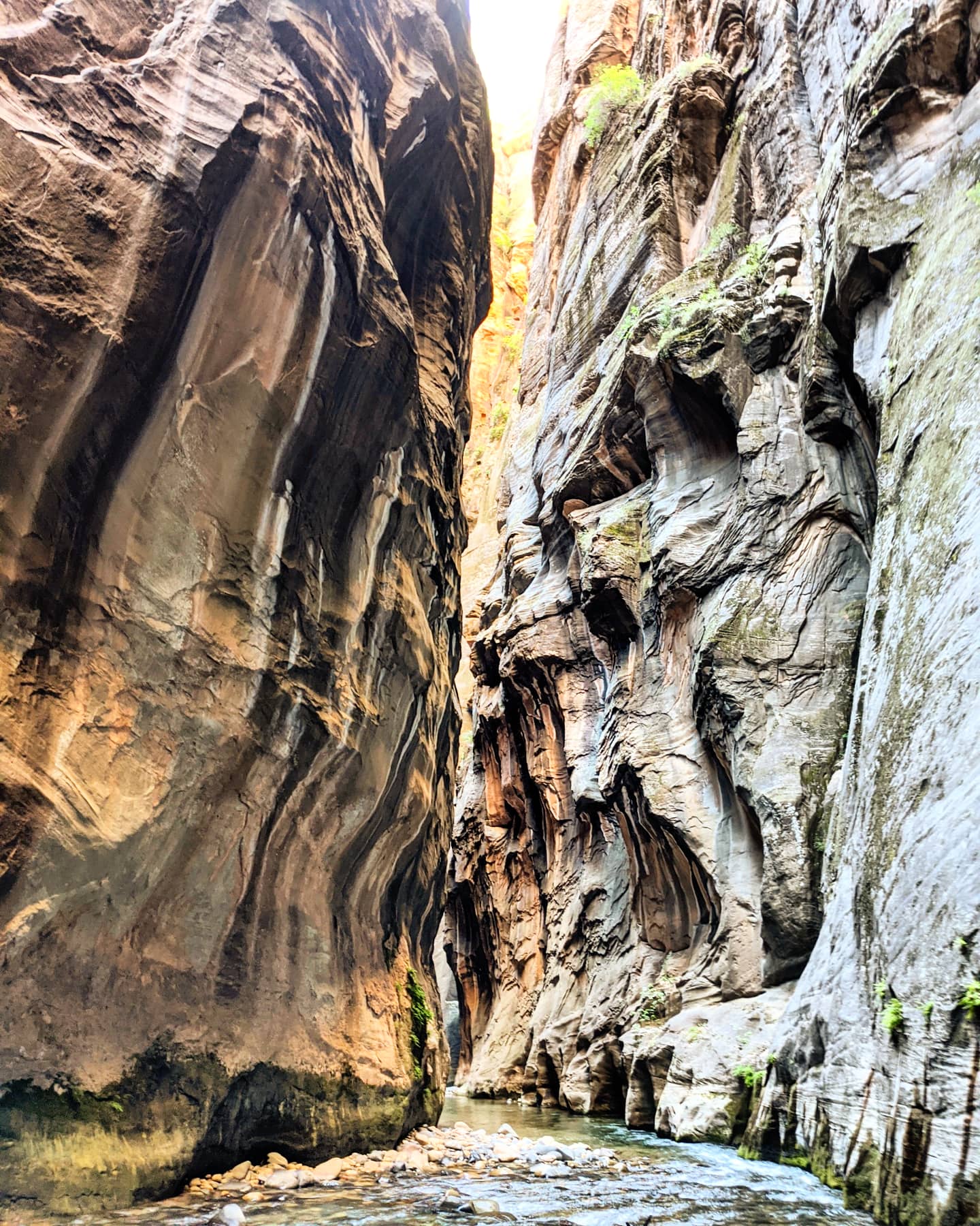
To make the most of Zion, you need to hike The Narrows, or at least I did. It was my Big To-Do for my entire stint in Utah, and much of my focus was placed on conquering the famed slot canyon. Making a full trek beginning from the park’s Riverside Walk puts you on the Narrows “From the Bottom Up,” a potential 10-mile circuit ending at an area known as Big Springs, after which only permit-carrying overnight campers are permitted.
Beyond being number one on my personal hit list, The Narrows is what most visitors come to Zion for, though the bulk will only venture in a mile or two before turning around. Either way, the crowds are notorious, so I set out as early in the morning as possible, catching the second shuttle to depart from the visitor’s center a few minutes after opening at 6 a.m.
Meet your guide
More Like This
Once again I found myself woefully unprepared, though at least this time I tried to gear up in advance. But the outdoor store I went to was sold out of trekking poles, and the outfitter located right outside the park — which rents out hiking kits for The Narrows including quick-drying clothing, shoes and a walking stick — didn’t open until two hours after I was already on the bus. Luckily, on my way down the Riverside Walk, I found a walking stick someone else had left behind. It was a fortuitous turn of event: balance is not my strongest suit. The challenge of The Narrows, you see, isn’t the distance, but the fact that you’re wading through water the entire time. Usually ankle deep, sometimes thigh high, occasionally up to your stomach or higher. The riverbed isn’t soft and silty, either. It’s lined entirely with slippery round rocks ranging in size from soccer balls to boulders. They’ve been worn smooth by the river, and many are covered in slick green algae (the algae bloom currently in the river is also toxic, so falling head first into the water and getting the cyanotoxin bacteria into your eyes is also not ideal).
I slipped and stumbled, though never fell, and after wading past the crowd from the first few shuttles soon found myself as the lead man of the pack. It was just me and the canyon bearing down from above, and around each rocky outcrop and jutting corner was one more unforgettable, stunning view of the jagged canyon walls, and then another, and another, the toxic bacteria even lending a pleasant tropical tinge to the water’s color.
My goal had only been to beat the rush, but now I was the first and farthest out for the day. My plans now shifted, and I needed to boldly go where, OK, sure, where hundreds or perhaps even thousands of people had gone before me, but none on that very morning as of yet: to Big Springs and back. Until, to my dismay, after about four outbound miles, a couple began approaching from the other direction, on their way back in. They beat me.
“I thought I’d be first,” I told the two from behind the neck gaiter I just pulled back over my mouth after a few hours of blissful, unimpeded fresh air.
“We didn’t quite make it. We turned around just 100 yards ahead, the water gets up to about here,” the woman said, indicating her shoulders, a point reaching the middle of my chest.
“That means you’re first now,” the man added.
“No point stopping then,” I told them.
Raising my drawstring bag above my head and hoping that the Ziplocs I had stashed within stayed watertight, I waded through the chest-high water, and a second, deeper stretch, to my shoulders, half a mile beyond. Finally, I reached Big Springs, the first one out and back for the day.
I completed my Big To-Do at Zion, I survived the early morning darkness at Arches, and both my car and I emerged unscathed from the flash flood. Finally out of the water and back on dry land five hours after I began my hike and five days after I first crossed into the state, I placed the walking stick back down where I found it, for whomever would need it next.
This article appeared in an InsideHook newsletter. Sign up for free to get more on travel, wellness, style, drinking, and culture..