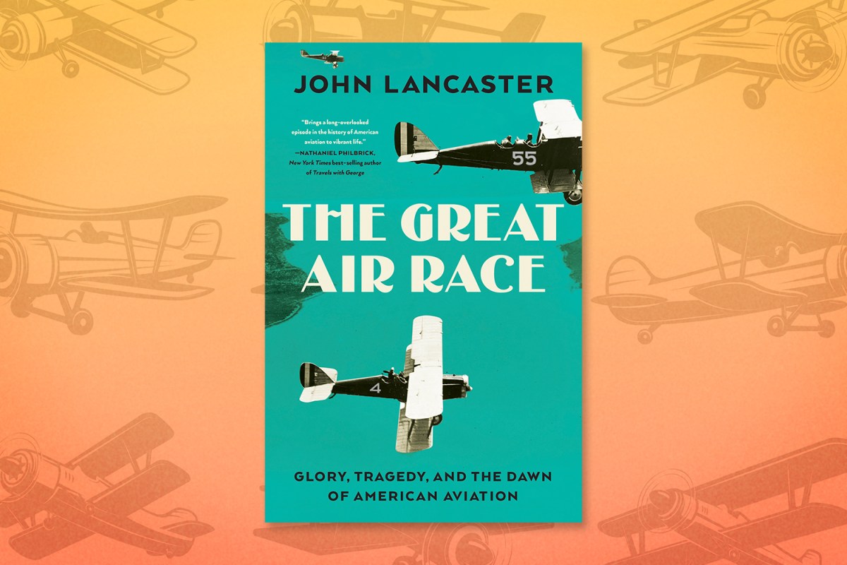
Consider the speed at which airplanes advanced in the early years of the 20th century. The Wright brothers first took flight in 1903, and by the First World War planes had become an essential part of the conflict. Once the war had ended, a different aspect of this technology came to the foreground: the ability of planes to travel long distances — and, in the process, captivate audiences on the ground. not for In his new book The Great Air Race: Glory, Tragedy, and the Dawn of American Aviation, journalist John Lancaster chronicles a race across the continent that took place in 1919. And if you think that some of the planes that existed at the time weren’t necessarily up for the task — well, you’re not wrong. Lancaster’s book chronicles the bravado, triumphs and tragedies of the aviators who took part in the competition, and we’re pleased to present an excerpt from it.
Weather forecasting in the United States had come a long way since the mid-nineteenth century, when the Smithsonian Institution established the first national network of weather observers. Scattered across thirty-one states, the observers kept daily records of temperature, barometric pressure, rainfall, and other data. They telegraphed their reports to Smithsonian headquarters in Washington, D.C., where the data were compiled into a crude daily weather map. But describing the weather was one thing; predicting it was another. In 1870, the U.S. Weather Bureau (now the National Weather Service) was created to do just that.
Signed into existence by President Ulysses S. Grant, the bureau initially relied on the Signal Corps, in partnership with civilian meteorologists, to generate its daily forecasts. Its first efforts dealt mainly with storms threatening the Great Lakes and the Gulf and Atlantic coasts. Forecasts for major cities soon followed, and in 1879 the bureau began publishing a daily national weather map that looks strikingly similar to its modern-day counterpart. Lines called isobars delineated areas of high and low pressure; arrows predicted the movement of storms. Closely spaced isobars indicated steep pressure gradients, which translate into higher winds. The weather maps were posted in hotels and railroad stations and published in newspapers across the country.
For obvious reasons, early aviators were eager consumers of the data furnished by the Weather Bureau, which had been taken over by the Department of Agriculture in 1891. Basic forecasts of surface winds and visibility at least gave them some way to plan ahead. But as airplanes flew higher and over longer distances, pilots recognized the need for forecasts tailored to the unique challenges of traveling through the atmosphere. Where could they expect clouds, and at what altitude? What about headwinds? Ice? Fog? Thunderstorms? Much depended on humidity levels and temperatures at various altitudes. Aviation forecasts would need to capture all of these variables and more.
The field of “aerology”—the study of the atmosphere—long predated powered flight. In the United States, it arguably can be traced to 1752, when Benjamin Franklin famously flew a kite in a thunderstorm to prove the link between lightning and electricity. The field expanded during the nineteenth century with the use of manned balloons to hoist scientists and their instruments aloft. But the method was impractical for daily samplings, so the Weather Bureau began experimenting with kites to carry its equipment. Starting in 1915, daily reports from a kite observation station in Drexel, Nebraska, were telegraphed to Weather Bureau meteorologists in Chicago and Washington, D.C. The data informed the bureau’s daily forecasts, but it only covered a portion of the Midwest and fell far short of aviators’ needs.
As with so many other aspects of flying, World War I made the quest for trustworthy forecasts more urgent. After the United States entered the conflict in 1917, the Signal Corps trained more than 500 men, many of them physicists and engineers, in the gathering and interpretation of weather data for both air and ground forces. Some members of the Army’s new Meteorological and Aerological Service were assigned to aviation units in France, while others remained in the United States to supply forecasts at training airfields. One of their most useful tools was the sounding balloon. Released to travel freely through the sky, it was tracked from the ground with a device called a theodolite, similar to a surveyor’s transit, revealing cloud heights as well as the speed and direction of winds aloft. Billy Mitchell considered this information so critical that he ordered sounding balloons sent aloft “every hour, night and day” while running air-combat operations on the Western Front.
Civilians followed the Army’s lead. On December 1, 1918, just weeks after the Armistice, the Weather Bureau began issuing daily aviation forecasts for the New York–Chicago airmail route. “Good flying weather today,” read one from the period. “Generally clear sky and good visibility, moderate varying winds surface and aloft.” By the summer of 1919, the bureau was making daily observations at kite stations in North Dakota, Oklahoma, Texas, Georgia, Indiana, New York, Michigan, and Washington, D.C.
The military continued to play an important role. In July 1919, the Air Service’s chief meteorologist began using Weather Bureau data to produce thirty-hour aviation forecasts covering the entire country, as part of the organization’s effort to boost commercial flying. Charles Menoher was careful to note that the Air Service was not “assuming any responsibility for accuracy.”
Mitchell had given careful thought to providing pilots in the transcontinental race with accurate weather information. Before the start, his office arranged with a Weather Bureau meteorologist in Washington, a Mr. Bowie, to telegraph local forecasts to each control stop twice a day. Bowie’s forecasts would supplement the weather observations made by the officers in charge, whose reports on surface winds and visibility were supposed to be transmitted by phone or telegraph to adjacent control stops daily at 8:00 a.m., 12:00 noon, and 3:00 p.m. At least in theory, flyers would then have some inkling of the conditions that awaited them at their next destination, if not along the route itself.
One important piece of missing data was the speed and direction of winds at various altitudes, which could affect navigation as well as fuel consumption between stops. The only exception was along a portion of the route through the Midwest. During daylight hours, meteorologists at the Fort Omaha Balloon School kept tabs on the winds aloft by means of a captive balloon fitted with an electric anemometer; their findings were transmitted three times a day to the Omaha control stop and to the control stops on either side of it: Des Moines, Iowa, to the east and St. Paul, Nebraska, to the west. Over most of the route, flyers had to rely on Bowie’s forecasts, which predicted the direction of winds aloft but not their altitude. For that, pilots could only make an educated guess.
The system had other gaps. The aviation forecasts issued by the Weather Bureau in Washington often failed to anticipate all but the biggest storms or got the timing wrong when they did. “Weather forecasts, in my opinion, are useless on a trip of this nature,” one pilot wrote after the race. The firsthand observations from control stops were helpful—but only when they were available and current. In many cases, pilots took off without knowing the weather at their next destination, either because of faulty communication between stops or lapses on the part of their commanders—many of whom, a pilot later complained, “did not seem to realize the importance of obtaining accurate weather reports before daylight about the weather conditions at the two adjoining control stations.”
Even if the control officers were diligent in their reporting, they could provide only a snapshot of the weather, which often changed quickly. Destinations that one minute were reported clear might be blanketed in fog by the next. Without radios, pilots would have no advance warning. During overnight stays at control stops, at least one pilot made a habit of visiting the local Weather Bureau office, if he could find one nearby, to scan the national weather map for clues to the flying weather ahead.
If he did so on the second morning of the race, he might have felt his stomach lurch. Issued in Washington at 8:00 a.m., the weather map for Thursday, October 9, painted a worrying picture. Isobars showed low pressure dominating the country from coast to coast. In addition, a shaded gray zone covered roughly a thousand miles of the route from Pennsylvania to Nebraska. Another gray zone was draped over the northern Rockies, where it intersected with the route in Utah and Wyoming. The gray areas indicated precipitation, which would come in the form of rain (symbolized by the letter “R”) in the East and Midwest and snow (“S”) in the mountain states. The map also predicted that temperatures in the West would drop well below normal for early fall, to 20 degrees Fahrenheit in some areas. It didn’t take an expert to know that both groups of aviators—eastbound and westbound—were in for a rough day.
Mr. Bowie, at the Weather Bureau, was the first to sound the alarm. On Wednesday, October 8, he had stayed late at his office in Washington, reviewing the latest telegraphed reports from field stations around the country. He was especially worried about conditions in the West. At 10:30 p.m. eastern time, he sent an ominous telegram to the control stop commander in Rawlins, Wyoming:
aviation forecast salt lake city to cheyenne on thursday flying weather will become bad period winds near surface will become strong northwest weather become cloudy with rain or snow and much colder period dangerous conditions in mountains
Thursday morning at 11:00 a.m., Bowie underscored the warning with another telegram to Rawlins. “Bad flying weather low clouds snow in the mountains,” it read. “Strong shifting winds probably northwest gales aloft dangerous conditions in Wyoming.”
Bowie’s forecast was timely and accurate. Few paid it much attention.
Nine of the fifteen planes to leave San Francisco had successfully completed the trip to Salt Lake City, where they had been grounded overnight on orders of the control stop commander. Flyers were eager to be on their way. They had agreed to depart the Utah capital at the same intervals by which they had arrived, to preserve their positions in the race at the end of the first day. Capt. T. S. Voss, the control stop commander, was still worried about the condition of the field at Green River, Wyoming, one stop to the east. Early Thursday morning, after consulting with headquarters, he told pilots they could skip Green River and fly direct to Rawlins, though if they did so they would need to add thirty minutes to their elapsed time over the route.
Control officers had the authority to hold contestants if they thought it was too dangerous to proceed. Given his evident concern for safety, Voss’s failure to do so on the second morning of the race is puzzling. Perhaps he never received Bowie’s forecast. Or perhaps he did but was skeptical of its accuracy. After all, forecasts were often wrong. On the other hand, even if he believed the forecast, how would it look at Air Service headquarters—and especially to Billy Mitchell—if he held up the entire contingent of eastbound flyers? Grounding pilots every time the weather was less than perfect would undermine one of the main reasons for the contest, which was to demonstrate the viability of long-distance air travel.
Moreover, these were military flyers, accustomed to taking risks. They had volunteered for the race and could exercise their own judgment on whether to continue. No one was forcing them to fly.
At Salt Lake City, at least, there was no obvious reason to delay. The weather was fine. In keeping with the gentlemen’s agreement reached the day before, Lowell Smith, who had been the first to reach Salt Lake City, would also be the first to take off. At twenty-seven, the former auto mechanic from California was an experienced pilot who was considered a top contender in the race. His aviation résumé dated to 1915, when Pancho Villa, the Mexican revolutionary, hired him to maintain his tiny air force, before Pershing’s troops crossed the border. The job, like Villa’s three planes, didn’t last long, but it did give him a taste for flying. He joined the Air Service in 1917 and spent the war as a flight instructor in Texas.
Smith lifted off at 7:33 a.m., followed by Emil Kiel at 7:51 and Carl Spaatz at 8:04. The soon-to-be-married Edward Wales, with his friend William Goldsborough riding in the rear cockpit, departed the field half an hour later. One by one, the four pilots turned east and began to climb toward the vaulting peaks of the Wasatch Range, expecting to reach Cheyenne in plenty of time for lunch.
What they didn’t know is that flying conditions on the other side of the mountains already had deteriorated. Just as Bowie had predicted, winter had come early to Wyoming. At 8:00 a.m., the control stop commander at Rawlins, Maj. Francis B. Longley, sent a telegram to his counterpart at Green River warning of dangerous conditions at the field. “Snowing with gradual increase in density,” Longley wrote, noting that the control stop’s limestone markings already had been “rendered invisible.” He advised the Green River commander to hold the eastbound flyers at that stop until the snow had abated.
The men who had just departed Salt Lake City would never get that message. Taking their cue from Voss, they had decided to fly past Green River rather than risk a landing on its waterlogged field. At some point during the morning, Voss got word of the treacherous conditions at Rawlins, perhaps after it was relayed from Green River. But by then it was too late.
Spaatz and Sgt. Emmett Tanner, his mechanic, crossed the Wasatch peaks at 12,000 feet, shivering in the frigid air, the shutters on the nose of the DH-4 closed to keep its radiator from freezing. As usual, Spaatz flew by compass to save time, crabbing to the left to compensate for a strong northwest crosswind. The flight to Rawlins would take about two and a half hours. Despite lowering skies, visibility along the route was good. Near Rawlins, he flew through a snow flurry, but he had no trouble finding the control stop at the town racetrack, which was easily identified by its grandstand and other nearby structures.
Spaatz circled the field and turned back into the wind to begin his final approach. As the aircraft settled toward the snow-covered landing area, he craned his neck over the side of the cockpit to get a better view, like the engineer of a steam locomotive rounding a bend—standard practice for DH-4 pilots, who otherwise could not see where they were going with the biplane’s long nose raised for landing. He touched down at 10:34 a.m., behind Smith and Kiel.
Smith had had a difficult flight to Rawlins, having flown through adverse weather that the others somehow avoided. He landed with his wings and fuselage caked in what he estimated was 200 pounds of ice. Much to his irritation, soldiers at the field had not been waiting to receive him, and he wasted precious minutes thawing oil over a fire before it could be poured into his engine. “No markers visible at Field, snow on ground,” Smith wrote in his logbook as he waited on the ground. “A very poor Field that I don’t believe a takeoff is possible.”
But Smith, eager to preserve his lead, quickly overcame his misgivings. After clearing his DH-4 of its frozen crust, he and his observer, Lt. Francis W. Ruggles, departed the field at 10:42 a.m., eight minutes after Spaatz’s arrival. Kiel took off at 11:08, and Spaatz took off at 11:16, following a twelve-minute delay in servicing his plane caused by the cold.
The three were now the front-runners among the eastbound pilots, separated by just a few minutes. If they had not already been fierce rivals, they were now.
The most dangerous conditions were still to come. After a nerve-wracking departure from Rawlins—with a full load of fuel and its climb performance diminished by the thin air, his plane had barely cleared nearby hills—Spaatz turned toward Cheyenne, 115 miles to the east on the far side of the Medicine Bow Mountains. At heights of nearly 12,000 feet, the mountains were daunting enough on their own, but now they were capped by dense gray clouds. He could see that it would be folly, and perhaps suicide, to fly the compass line to Cheyenne.
Reluctantly, Spaatz decided to follow the railroad. Though it would add about seventy-five miles to his route, flying along the tracks would avoid the highest terrain.
But it wouldn’t keep him out of the snow. Minutes after he took off from Rawlins, a blizzard—Spaatz called it a “snow hurricane”—enveloped his plane, reducing visibility to 200 or 300 yards. Spaatz feared that he might lose sight of the ground and descended to just fifty feet above the tracks, swerving to avoid water towers that appeared suddenly out of the swirling snow. After skirting Elk Mountain to the north, the tracks turned southeast and entered a series of narrow canyons between Laramie and Cheyenne. With clouds forming a barrier overhead, he had no choice but to thread his way through the treacherous maze, banking sharply with every twist and turn of the rails. It took all his concentration and skill.
Much to his relief, Spaatz exited the last of the canyons into clear skies. Just ahead lay Cheyenne and the big landing field at Fort D. A. Russell. The only threat now was the wind, which howled out of the north at between fifty and sixty miles an hour. As Spaatz touched down at 12:43 p.m., a gust rocked his plane so violently that a wing skid broke against the ground.
Smith and Kiel also had followed the railroad to Cheyenne. “It was snow and blow all the way,” Smith told a reporter the following day, adding with a touch of melodrama, “Death was at our elbow.”
Wales and Goldsborough, in the fourth plane to leave Salt Lake City that morning, landed at Rawlins at 11:05 a.m., while Spaatz and Kiel were still on the ground. At this point none of the men had any reason to doubt the hazards that awaited them just to the east. Snow was falling nearby, and Bowie’s warning had been telegraphed to the control stop at Rawlins the night before. Nevertheless, after talking through the risks, Wales and Goldsborough rejected the safer option. They would follow their compass instead of the railroad.
Their reasoning is easy enough to grasp. Everyone understood that the race’s official name—the “Reliability and Endurance Test”—was a little misleading. As Mitchell himself had acknowledged in a letter to Arnold in late September, the contest was “really a race,” and the Air Service had treated it as one from the beginning. The Air Service News Letter of October 8 called it “a sporting event.” The Air Service Information Group in Washington tracked flyers’ progress on a nine-foot-wide “score board” showing their arrival and departure times—down to the second—at each control stop. Control stop commanders, who provided the data by telegram, sent duplicates to the American Flying Club in Manhattan, which passed it on to the press. Newspapers obliged with banner headlines and urgent, horse-race-style coverage, including agate lists of flyers and their times between stops.
Inevitably, the emphasis on competition pushed flyers to take risks they might otherwise have avoided—as one contestant later put it, “the human element is anxious to get there first.” As they waited on the ground at Rawlins, Wales and Goldsborough knew they were near the front of the pack, with a fair chance to take the lead. And they wanted to get there first. They took off from Rawlins at 11:39 a.m., just twenty-four minutes behind Spaatz.
In better weather, the direct route would have posed no great challenge, but the DH-4’s few instruments were of little help in the blinding snowstorm that Wales and Goldsborough encountered some twenty minutes after leaving the control stop. Now, as they approached Oberg Pass, they faced the consequences of their gamble.
Wales had been flying low to keep the terrain in sight. His aircraft was only about 150 feet off the ground when he tried to turn away from the side of Coad Mountain, glimpsed too late through the veil of snow. Like Crissy the day before, he stalled the plane and tipped it into a spin, with no time to recover. The DH-4 spiraled to the ground, coming to rest with its fuselage mostly intact but its wings broken and askew.
For a few minutes all was quiet save the muffled sounds of mountains in snow. Wales slumped motionless in his cockpit, wedged between the gas tank and the engine, blood pouring from a ragged hole in his forehead. Goldsborough, too, was unconscious, but his injuries were superficial and he soon recovered his senses. He extricated himself from the wreckage and then did the same for Wales. Despite the snow and piercing cold, he pulled off his clothing and tore strips from his underwear that he used to bind Wales’s wounds. He covered the pilot with his flying coat, built a small fire with wood salvaged from the wreck, and propped up a broken aileron as a wind break. Then he stumbled off through the blizzard, his remaining clothes splotched with Wales’s blood.
His plan was to find the ranch house he had seen from the air shortly before the crash. But Goldsborough was disoriented and set off in the wrong direction. Desperate and underdressed, he half-ran, half-skidded down the slope of Coad Mountain, skirting boulders and clumps of lodgepole pine. Sometimes he slipped and fell in the snow. Eventually he spotted another ranch house, in a basin about five miles from the downed plane. A rescue party was quickly organized. Cowboys saddled their horses, loaded them with blankets and coats, and headed back up the mountainside.
They had no difficulty following the trail made in the snow by Goldsborough’s footsteps and the impressions of his body where he had fallen. But the rescuers arrived too late. Wales had been dead for hours.
Reprinted from The Great Air Race: Glory, Tragedy, and the Dawn of American Aviation by John Lancaster. Copyright © 2023 by John Lancaster. Used with permission of the publisher, Liveright Publishing Corporation, a division of W. W. Norton & Company, Inc. All rights reserved.
Meet your guide

More Like This

This article appeared in an InsideHook newsletter. Sign up for free to get more on travel, wellness, style, drinking, and culture.