
Welcome to 17 Miles, a travel series built on one core belief: the best way to know a city is to run through it. Whether you’re a serious marathoner, a business traveler or a hungover wedding guest desperate to sweat it out, we’ve personally mapped the best routes — and scouted the right stops to match.
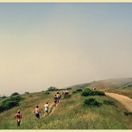
Careful dashing around corners in Charleston.
The South Carolina city’s pace remains decidedly slow — from retirees peering at porch pineapples in the historic district to window-shoppers ambling in sundresses along King Street to CofC zombies hunting for hangover cures.
Running through the city feels somewhat contrarian to its slowpoke soul. But it’s a richly rewarding experience anyway, a chance to explore as much of Charleston’s labyrinthine downtown as possible, while granting you access to neighborhoods that feel more residential and more real — like Racliffeborough, Hampton Park Terrace and Mount Pleasant.
Charleston has changed a lot over the last decade: plenty of rooftop bars now mix with the town’s famous church spires, catering to the bachelorette coteries, while waterfront condos house the pandemic-era tech set who never left. The city appears to be picking up speed. At the very least, there are more runners out there than ever before.
You’ll find them tracing the edge of Waterfront Park, the flags of Fort Sumter fluttering on the horizon. Chasing loops around Hampton Park’s dusty outer trail. Or even climbing Ravenel Bridge, host to the Cooper River Bridge Run, a beloved 10K race in early spring, which is the best time of year to run around here.
Soon enough, a new pedestrian bridge will connect the city to the 10.5-mile West Ashley Greenway. And the Lowcountry Lowline, a linear park (and a riff on NYC’s High Line), will offer another corridor. Meanwhile, run clubs like Let’s Run CHS and upstart athletic club Ethos are hosting sunset runs on Sullivan’s Island and track workouts at The Citadel.
We came to town in late March. Here’s where to catch some Zs, fuel up and run 17 miles.
⇢ SLEEPS ⇢

Hotel: The Loutrel Hotel
Where is it: Historic District
What works: It’s a 50-room boutique in the French Quarter, just two minutes in each direction from the city’s most iconic old landmark (City Market, 1790s) and its most iconic new-ish one (Pineapple Fountain, 1990s).
I arrived on a Wednesday afternoon to a bright, open-plan lobby, with red-velvet-covered cherries and “sweet heat” nuts on offer. I was pumped about my bed — a California king with percale sheets — which promised deep recovery for my soon-sore legs.
The reality of all the running I owed set in as I leaned on my room’s Juliette balcony. In the distance, the Arthur Ravenel Jr. Bridge carved its way across a vista of symmetric Georgian rooftops and yellow bell towers. The steep bridge, with a pair of cable towers shaped like sibling sailboats, was firmly on the menu — the anchor to a seven-miler I’d scheduled for Thursday.
But first, I unpacked my things and laced up for my day-one effort, which I conceived as the running version of a “hop on hop off bus” — an exploratory session where I could knock out the sights I needed to see, without straying too far from the hotel, in an efficient four-mile package.
All throughout my stay, I relied on The Loutrel’s ease of location and large, chilled rooms. When the sun started to sink, I took the elevator to the roof-deck to play with the day’s GoPro footage, eat three rooms’ share of tuna tartare tacos and sip nectar gin cocktails. It’s a difficult job, but someone’s gotta do it.
⇢ MILES ⇢
Run #1: Historic District
- Miles: 4.0
- Elevation gain: 20 feet
- Run type: City sidewalks, waterfront
- Where to start: Waterfront Park
If you’ve ever run in Charleston, you’ve probably done some version of this route.
The run begins in the French Quarter, near Waterfront Park, and quickly cuts past the Pineapple Fountain. (In my opinion, this doesn’t necessitate much of a stop — it’s an endlessly-orgasming concrete pineapple.) If anything, I’d recommend jogging out to the pier, where the temperature immediately drops a couple degrees and the harbor reeds dance in salty breeze.
You’ll get a panoramic view here: Charleston’s casual skyline, Mount Pleasant on the opposing coastline (which reaches towards the Atlantic beaches) and far out, to the southeast, the red-brick Fort Sumter, where the Civil War’s first shots rang out in 1861.
I followed the sidewalk south until a construction closure briefly sent me into the Historic District’s maze of single houses (long, narrow lots with one street-facing gable each), where the claps of hooves on cobblestone are standard, golf buggies are parked in the driveways and shaded porches advertise the state’s excellent branding: the white palmetto against a night-sky blue.

By some providence I found my way past the jackhammers and back to the water. I passed Rainbow Row and curved my way down to the Battery. The pedestrian pathway is elevated above the road here, which offers a visual feast. To the left, more harbor, more coastline, the Ashley River bridges. To the right: peak Chucktown curb appeal. Good for these people, I thought to myself, generously.
I wouldn’t want to run for this stretch too long — and especially not in summer. There’s no tree cover to speak of. But Murray Boulevard, as it’s called, has a fair share of off-ramps (Limehouse, Council, Rutledge) via which runners can re-enter the city’s sleepy, shady downtown.
I took a right on Tradd Street — mere blocks, a friend later texted me, from Colonial Lake, a tidal pond where he used to run loops — and completed the last mile-plus of my run amidst the colonial side streets. How odd, walking around these heritage neighborhoods. Gnawingly perfect little coves of history, so accessible and yet so prohibitive. If you’ve been to Georgetown in Washington, D.C., or Alexandria, Virginia, or even parts of New York City’s West Village or Brooklyn Heights, you’re familiar with the feeling.
I turned off the music in my ears, wiped some salt from my neck and walked the rest of the way back to the hotel. Four miles down. The city’s churches harkened five o’clock. It was time for a shower and a drink.
Run #2: Ravenel Bridge
- Miles: 7.0
- Elevation gain: 213 feet
- Run type: Bridge climb, suburbs
- Where to start: Mount Pleasant Historic District
My Uber driver was confused when she dropped me off on a suburban street in Mount Pleasant. It was early, there wasn’t even a lawn mower out and seconds after leaving her car, I’d started hopping up and down like a title-challenging boxer.
“What’s even over here?” she asked.
“Oh! I’m gonna run the bridge!”
“The one we just drove over.”
“Yes.”
She laughed and wished me luck. I appreciated the ride over — for one, it was only $12. But it also gave me a chance to study the industrial anatomy surrounding the bridge. Where’s the path? Is there a sidewalk leading up to it? Best place to turn from the residential area onto the highway? And so on. I knew this would be the grittiest run of the trip, on top of being the longest, and I didn’t want to run the wrong way (or wrong headlong into an 18-wheeler).
Still, it would be comically misleading to call the opening miles in Mount Pleasant “gritty.” The place is a latter-day pleasantville, with waterfront mansions that have tripled in price over the last 20 years. Think sprinklers, American flags, Porsche-laden cul-de-sacs, neighbors who talk to each other.
I enjoyed looking at the homes as my run got going, my legs slowly groaning into a reliable rhythm for the effort ahead. The residential area gradually gave way to the Old Village Historic District (folksy pharmacy and post office), then abruptly gave way to a gravel path, which I followed into the back parking lot of an oyster joint.

I ran over a rickety fisherman’s foot bridge and merged with Coleman Boulevard. It actually is a highway (SC 703), but presents more like a commercial thoroughfare, with strip malls, fishing charters and burger joints dotting either side of the road. It’s the sort of violent, smelly running you sometimes have to deposit in order to cash in on something transcendent.
Along the way, I spotted official flags for the Cooper River Bridge Run, which would come to town in a week’s time. They start by a middle school in Mount Pleasant, and run all the way to Marion Square, a park about three-quarters of a mile from my hotel. I tried to imagine some 40,000 runners sweeping up this street.
The bridge’s western tower appeared and stayed fixed in my eyeline for a while, a volcano at the end of a long road, before I’d finally made enough progress to see the entrance ramp. It’s called Wonders’ Way, named for Garrett Wonders, an elite cyclist who was killed in a collision with a vehicle in 2004, in the nearby town of Goose Creek. When Ravenel opened to traffic in 2006, advocates made sure there was a 12-foot-wide protected lane, cleanly divided for cyclists and pedestrians alike, of which there were many.
I’ve run a lot of bridges in my life, some of them puzzlingly dangerous, so I really appreciated how safe it was. Or, I’m able to now, at least — at the time I was more preoccupied with getting oxygen into my lungs and holding on to my beloved On running hat. It’s a steep, blustery climb.
Well-worth it once you’re up there, though, the lowcountry rippling for miles in every direction, like a family quilt. I peered over the edge, even pirouetted without breaking stride at the top: dinghies chugging under the soffit, waves crashing against Sullivan Island, airliners descending into Charleston International.
It’s a while up on the bridge, nearly three miles, but the last great chunk of that distance is a steady downhill, which curves into the outskirts of the city. When I was finished I stumbled into a perfectly-placed bubbler. Thank the gods. Or, probably, Charleston County Parks.
Run #3: Hampton Park to Citadel Track
- Miles: 6.0
- Elevation gain: 19 feet
- Run type: Park trail, track
- Where to start: Hampton Park
My favorite run of the trip. Go figure!
Hampton Park is a 60-acre, multi-use commons in North Charleston. It’s a complicated place — named for a Confederate general, but also home (since 2014) to a statue of Denmark Vesey, a free Black man and the leader of a slave revolt in 1822.
During the Civil War, this place was a prisoner-of-war camp for Union soldiers. Their remains are buried in a mass grave in the spot of a former Italianate grandstand, where thousands used to convene each February in the early 1800s to watch horse races. The thoroughbreds are long gone, but the route they galloped along is now Mary Murray Drive, a one-mile route that encircles the park.
As a regular runner, let me tell you, a one-mile loop is a true gift. Made better, just inside of the road was a dirt track —dusty, easier on the joints than asphalt and shaded in Spanish moss. I flew around the perimeter of the park, racking up miles, watching in-laws set up chairs for a wedding and little kids bumble through a game of tee-ball.
The nice thing here is if you get sick of the park (unlikely, unless you’re getting eaten alive by bugs, which happens depending on the season), you can shift one common area to the left.
All throughout my loops, I’d heard the thunder of cannon fire from an exercise at The Citadel, the military college next door. There’s a gate just off Hampton Park, via which you can easily enter the campus, and less than a quarter-mile, through a parking lot, there’s the school’s jet-black track.
At this point, I was sitting on exactly 16 miles. The drama! I cruised through the final four laps of my trip, logging a 6:22 to really seal the deal. Next to the track, under a Southern live oak, I found a row of pull-up bars, the taped grips ratty from who knows how many screaming knuckles. I hung there for a bit to release my back, and felt peace cover me from head to toe.

Honorable Mention
Charlestonians have it good. I caught up with a friend of mine on Friday who’d been stuck on Zoom all day. When it was finally time to shut the laptop, he had an immediate plan to salvage the day. We drove out to Sullivan’s Island, with his duo of dogs, to walk up and down the beach. Both Bill Murray and Stephen Colbert apparently have homes in the neighborhood.
Bachelorette parties were eating pizza as puppies burned their supply of zoomies in the surf. The sun bounced off the black-and-white Charleston Light, floodlighting purple lovegrass in the dunes. We walked through the grid of stilted neighborhood mansions to a flip-flop avenue where people drink beers outside and eat lots of guacamole.
I definitely could’ve run here. Maybe I will one day. Here’s how I’d do it: take an Uber (or park a car) at Santi’s, a Mexican cantina off Ben Sawyer Boulevard. There’s a clutch sidewalk on the right side, protected from the road, which you can follow over Ben Sawyer Bridge, all the way into the town of Sullivan’s Island.
Once there, I’d take a left on Middle Street, head down as far as Station 31, then take a right and make your way back up the coast. Run on the road next to the dunes, or head down to the water itself. (There’s no boardwalk, heads up.) From there you could wrap up the run somewhere like Mex 1 Coastal Cantina or Sullivan’s Fish Camp — or, if your car’s still waiting at Santi’s, double back to the parking lot.
⇢ PITSTOPS ⇢

I actually went to Second State on a lark one day — then came back for a second day because I had such a nice experience. It’s on a corner in a quiet part of town. Good wifi, great muffins.
Charleston likes its craft beer, with standouts including Revelry Brewing Co, Charles Town Fermentory and Edmund’s Oast Brewing Co. All can be found in the city’s northern reaches. I popped into Palmetto Brewing Co after my third and final run to pick up a six-pack of salted-lime lagers before meeting a friend. Unfortunately, after 30 years in business, the brewery officially closed its doors this summer.
Perfect location a stone’s throw from the water, the walls are smothered in greenbacks, great beer selection, the game’s on. I came to The Griffon for a happy-hour cold one, but it’s open until 2 a.m., so you’ve got no excuse. A must pop-in.

I can’t think of a better menu for a running vacation. Grain bowls, avocado toast, breakfast burritos, all manner of artisanal goodies. Alcove Market is an ideal spot to hit after wrapping up that first run, the four-miler through the Historic District.
What a pleasant curveball this place was. The Loutrel was gracious enough to link me with Ethos, an ascendant athletic club with real clout in Charleston’s fitness community. The two groups collaborate on a package for wellness-minded travelers.
Ethos is a massive gym (you could wedge a Home Depot in there) with garage doors, industrial fans, an artillery of weight racks and cardio machines — the works.
I visited the place a few hours after my bridge run. My legs were wobbly, and I wasn’t entirely sure what they had in store for me. Had it been a HIIT workout, I would’ve issued a mental “fuck,” then smiled and burned another 1,200 calories. (This is the life of a wellness writer.) After all, I was meeting with Katie Blaylock Sharpe, who spent years training professional athletes for Nike before opening Ethos with her best friend, Joey Welling.
Fortunately, Katie just wanted me to demo the gym’s contrast therapy studio. Out back, enclosed in a little yard, Ethos had installed a sauna hut, and an ice bath, which was built atop a wooden platform, like a stage. I lasted for five minutes, aided, I have to say, by a Sam Fender song that Katie graciously blasted from the backyard speaker system.
When I emerged, it was another guy’s turn, a strength coach for the local hockey team, the South Carolina Stingrays. I told him what I was doing in Charleston: 17 miles over three days. The routes I’d chosen. He said good choices. And also: huh, that’s a lot of miles.
My legs agreed with him, later — when it was time to board the plane home. But right then and there, they just buzzed and hummed. They felt like they could go anywhere at all.
Meet your guide

More Like This

The Charge will help you move better, think clearer and stay in the game longer. Subscribe to our wellness newsletter today.